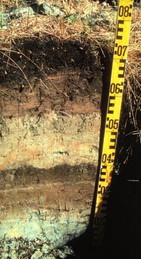
This photograph, from the west coast of Vancouver Island, clearly shows the effects of subsidence and tsunami deposition. The sandy layer from 04 to 05 is tsunami sand associated with the 1700 earthquake. The underlying brown layer is soil which had developed prior to 1700.
(from: Clague, J. and Bobrowsky, P., 1994, Evidence for a large earthquake and tsunami 100-400 years ago on western Vancouver Island, British Columbia, Quaternary Research, V. 41, p. 176.)