|
FRST 328 GIS
TERMS &
CONCEPTS
The
following is a listing of the material with which you should know. It forms the
basis of test material. Obviously wording on tests will vary from what is
presented below.
Introduction to GIS (links
provided go to the ESRI GIS Dictionary)
-
in YOUR
OWN WORDS, define/describe GIS (geographic
information system)
-
compare GISystems, GIScience, GIStudies
-
not
including da Boss, describe three types of GIS "jobs"
Spatial Data
-
define spatial referencing
(aka georeferencing)
-
differentiate
between geographic vs. Cartesian
coordinates
-
define: graticule,
ellisoid, geoid, datum, MSL
-
define
datum and why it's important for GIS
-
define
map projection and why it's important for GIS
-
state meaning for the acronyms (for spatial data): NTS,
BCGS, TRIM, VRI, TEM, SEI
Build a
Geodatabase
-
your mission, build
a geodatabase for a new Woodlot - outline how you would approach this task
-
define and be
able to compare: scan & digitize, manual & heads-up digitizing, cogo,
geocoding
-
define remote
sensing and describe how it relates to GIS
-
what is image
classification
-
how does traverse
data makes it's way into a GIS?
Cartography
-
Briefly describe
basic map elements
-
Describe what maps
communicate (relates to Dr. Seuss)
-
describe, in
some detail, cartographic (map)
design
Classification
-
be able to
define the methods and to
classify data
according to
-
quantile
-
equal-interval
-
natural break methods
-
std. deviation
-
as per the link "How to
Choose", outline the advantages/disadvantages of each method of classification
Database &
Attribute Data
-
define (and provide examples as
appropriate)
-
database, DBMS
-
field, field name, record
-
primary key (key field), secondary key
(foreign key), unique identifier
-
field types: text/string, short & long integer, single &
float real numbers
-
precision
& scale
-
outline the advantages of
database
-
list 3
parts of a query
-
differentiate between the
Boolean operators: and,
or, not ... provide examples for each
-
describe how database relates to GIS
-
describe/differentiate each of
the following
Vector Analysis
End for Midterm
==========================================================================
Analytical (Cartographic) Modeling
Spatial Data Modeling
-
Terms:
-
discrete
objects vs. fields
-
vector
vs. raster
-
pixel,
pixel resolution, extents,
-
spatial
entity types, topology
-
Describe data modeling
-
describe each phase of data
modeling
-
for any given real world
phenomena (e.g. lakes, wetlands, lookout towers, roads, etc.) discuss
how it could be captured in both the conceptual and logical data models
-
What are the five spatial
entity types (point, line, network, polygon, surface) and provide
examples for each and describe how they relate to the conceptual model
-
Describe how discrete objects ( a
point, a line, a polygon) are represented in a vector model ... in a raster
model
-
Describe how continuous
variables are represented in a vector model ... in a raster model
-
Compare the
spaghetti and topology vector models
-
Describe
the generic file structure of a raster file; also what type of data is
contained in the 'header' or 'world file'
-
Compare the
advantages (disadvantages) of vector vs. raster
-
Note we are NOT covering the details regarding the
Physical Model - all you need to know is that the physical model is the
actual "digital structure" (i.e. "the computer code") and each software will
have a different physical model.
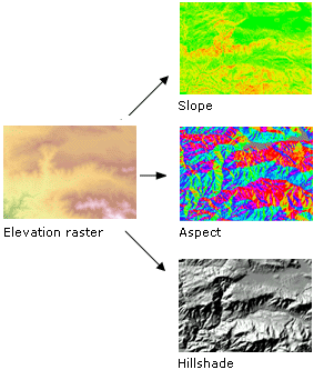
Raster Analysis
Data Acquisition
-
Define: COGO, rubber sheeting, edge-matching,
primary & secondary data sources, metadata, data warehouse
-
List primary & secondary data sources
-
what is the difference
between 'tablet digitizing' and 'heads-up' digitizing?
-
What are the other 5 types of generalization (provide diagrams)
-
what is topology and what are it's benefits (there are 2: one relates to
analysis and the other to data)
-
Define: "noise", COGO, point mode
digitizing, stream mode digitizing, map registration,
loops/spikes, over/undershoots, rubber sheeting, edge-matching, primary &
secondary data sources, metadata, data warehouse
-
Describe the 'GIS data
stream' (and provide a diagram)
-
With regards to digitizing:
-
list the steps in the
digitizing process; what step is most time consuming?
-
What is 'prepping/cleaning a map'?
-
what is the difference
between 'tablet digitizing' and 'heads-up' digitizing?
-
With regards to scanning a map:
-
compare flatbed vs. drum
scanners
-
what happens to dashes and
symbols?
-
list the steps in
scanning; what step is the most time
consuming?
-
With regards to editing
-
what are the typical errors that
need to be corrected?
-
what types of functions are
carried out in "geo-processing"?
-
differentiate between edge
matching and rubber sheeting
-
what are the 2 types of
map generalization that are particular to digital maps? Which type
is more likely to be used with stream-mode digitizing?
-
What are the other 5 types of generalization (provide diagrams)
-
what is topology and what are it's benefits (there are 2: one relates to
analysis and the other to data)
Data Quality
-
Define/ describe
-
error/uncertainty, resolution, MMU,
metadata
-
completeness vs.
consistency vs. compatibility vs. applicability
-
absolute and relative positions
-
nominal vs ordinal vs interval vs ratio measurement
scales
-
primary vs secondary data
-
Discuss sources of error/
uncertainty regarding spatial data in GIS
(be sure to
include: data modeling, data capture, encoding,
integration and output)
=======================================================================================
|