Debris Flow Defensive Structures at
Howe Sound
British Columbia, Canada
 Howe Sound is a glacially carved fiord which extends from
Horseshoe Bay (20 km northwest of Vancouver) to Squamish. This region is
particularly prone to debris flows because of the steep glacial-valley
slopes. The
problem is exacerbated by a loose mantle
of glacial sediments on those slopes, and by periodic heavy rains. Human
activities, including tree-harvesting on some of the steep slopes and the construction of a railroad and a major
highway have added to the risk of slope failure. Because of the steepness
of the slopes, most of the small communities in this area have been
built on the fans created by former debris flows - putting them in the direct
path of future debris flows.
Howe Sound is a glacially carved fiord which extends from
Horseshoe Bay (20 km northwest of Vancouver) to Squamish. This region is
particularly prone to debris flows because of the steep glacial-valley
slopes. The
problem is exacerbated by a loose mantle
of glacial sediments on those slopes, and by periodic heavy rains. Human
activities, including tree-harvesting on some of the steep slopes and the construction of a railroad and a major
highway have added to the risk of slope failure. Because of the steepness
of the slopes, most of the small communities in this area have been
built on the fans created by former debris flows - putting them in the direct
path of future debris flows.
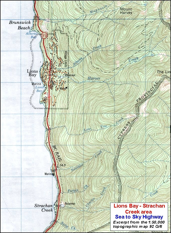
 The
steepness of the slopes of the Howe Sound area can be seen from the topographic
map. Stream-bed slopes in this area are commonly in the 20 to
40°range, and are as high as 57° in some cases (Lister et al., 1984).
Slopes
outside of stream beds tend to be even steeper.
The
steepness of the slopes of the Howe Sound area can be seen from the topographic
map. Stream-bed slopes in this area are commonly in the 20 to
40°range, and are as high as 57° in some cases (Lister et al., 1984).
Slopes
outside of stream beds tend to be even steeper.
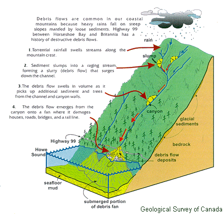
The sequence of events that can lead to debris
flows at Howe Sound is summarized on the diagram below.
To begin with heavy rains on slopes that
are already covered with snow produce very large stream flows in the upper-slope
areas. The high flows create instability on the stream banks, causing
loose overburden, snow and ice and even trees to slump into the flowing
water. Where the debris flood emerges from the incised stream valley onto the
pre-existing fan area it spreads out, causing damage to buildings, bridges,
roads and the railway.
 Since 1921 there have been at least 48
deaths and millions of dollars of damage
to private property and public infrastructure, related to debris flows in the
area between Horseshoe Bay and Squamish (Evans and Savigny, 1994).
Since 1921 there have been at least 48
deaths and millions of dollars of damage
to private property and public infrastructure, related to debris flows in the
area between Horseshoe Bay and Squamish (Evans and Savigny, 1994).
During the past two decades major efforts
have been undertaken to reduce the potential for damage, injury and loss of life
on this important transportation corridor. Some examples of these are
shown on the photographs below. The photographs were taken in the areas of
Harvey and Alberta
Creeks at Lions Bay, and Charles Creek at Strachan Creek (as shown on the topographic
map.)
 |
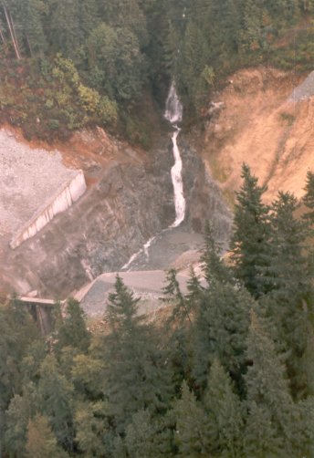
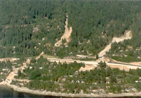
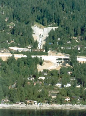
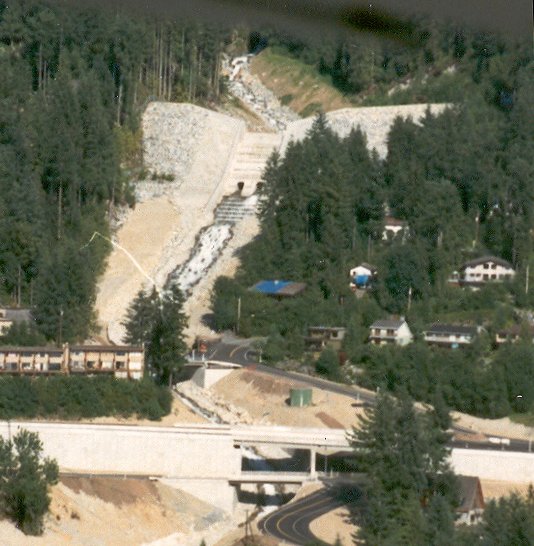
Charles Creek and the village
of Strachan Creek.
The upper parts of the drainage system is
characterized by extreme slopes and sparse vegetation.
The houses are built on an alluvial
fan from Charles Creek. The British Columbia Railway (below) and the
Sea to Sky Highway (99) are visible.
The debris flow retention structure is
situated immediately above the highway.
|
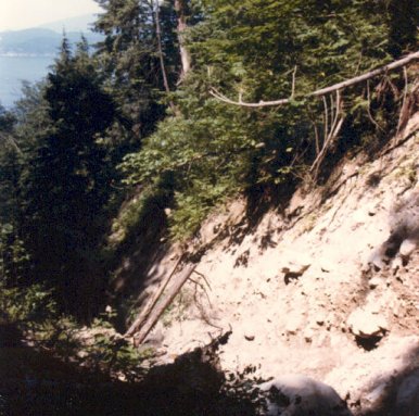 |
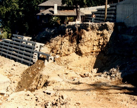
Overburden (alluvial and possibly
glacial) exposed in the bed of a stream draining into Howe Sound. |
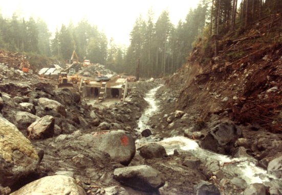 |
Construction of a concrete culvert on
one of the Howe Sound creeks.
(Location unknown) |
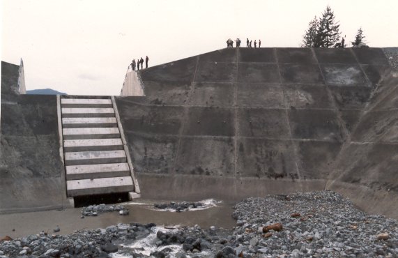
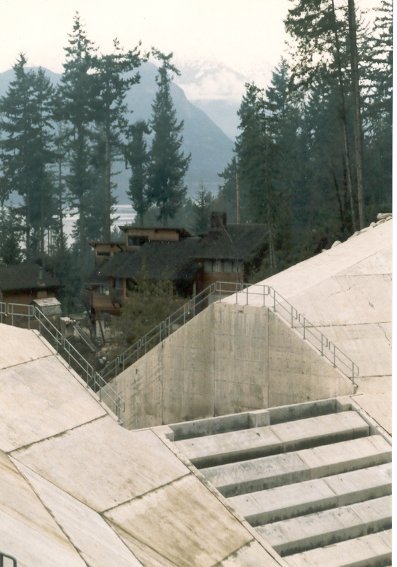
 |
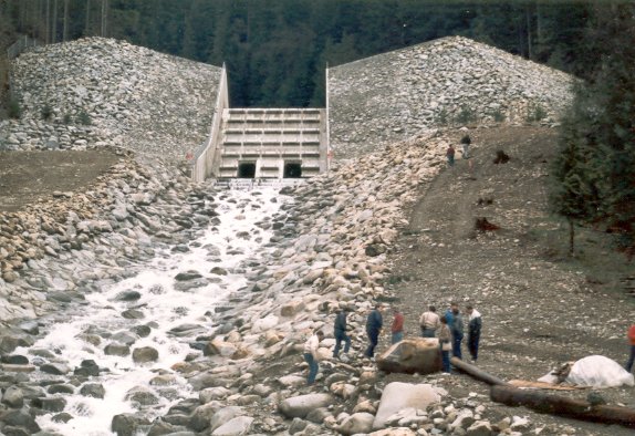
Aerial view into the basin
behind the retention structure at Charles Creek.
Sediment and organic material from a
debris flow will collect in this basin. The basin can be cleared out
after a major debris flow.
|
 |
View from within the retention
structure at Charles Creek. |
 |
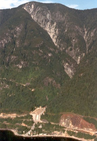
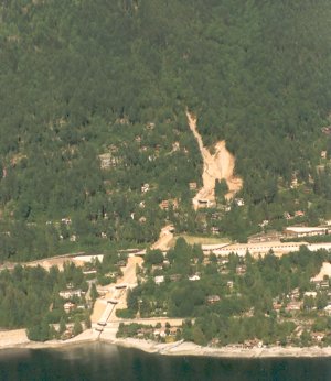
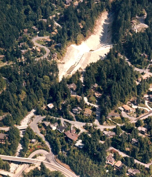
Aerial view of the town of
Lions Bay. The settlement has been built on the alluvial fans from Alberta
Creek (left) and Harvey Creek (right).
The British Columbia Railway is close to
the water's edge. Highway 99 passes through the centre of the town.
|
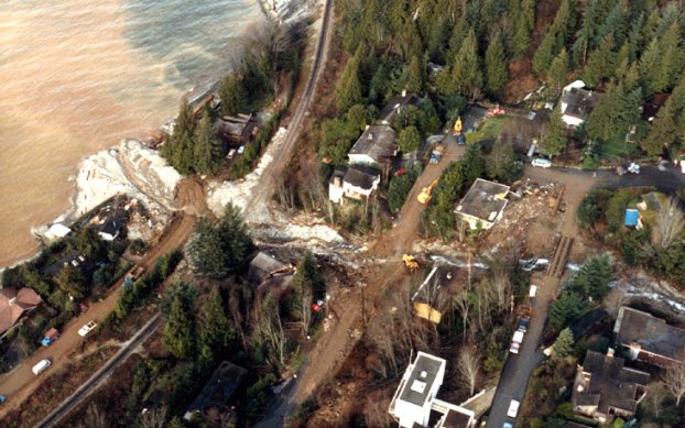 |
Aerial view (looking north) of the
1983 debris flow on Alberta Creek in Lion's bay. Note damage to roads, the
railway and to buildings. |
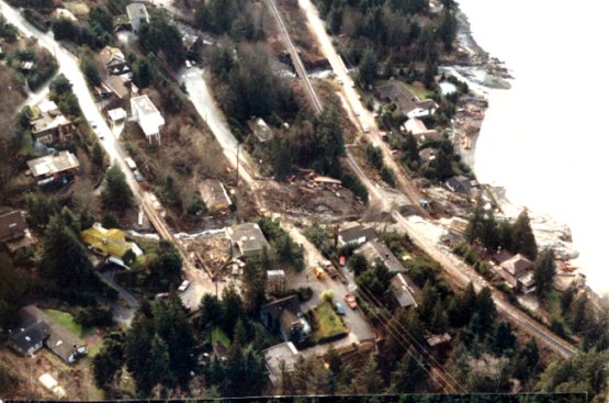 |
Aerial view (looking south) of the
1983 debris flow on Alberta Creek. |
 |
Aerial view of Alberta Creek at
Lions Bay with the concrete flume under construction. |
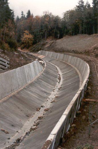 |
Concrete flume under
construction on Alberta Creek in the upper part of Lions Bay.
The flume is designed to allow water, mud
and debris to pass unimpeded during major flooding events.
|
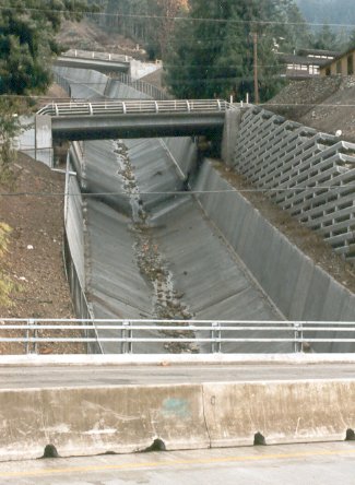 |
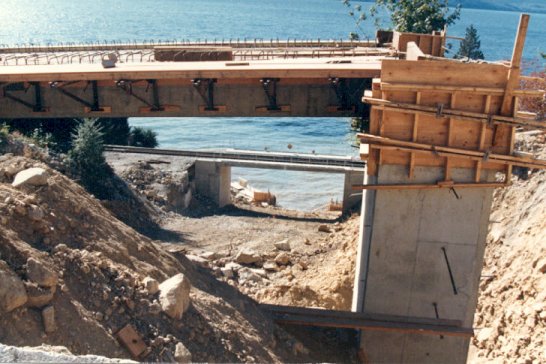
Concrete flume on Alberta Creek
with road and highway crossings. |
 |
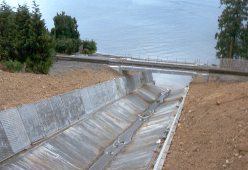
Completed concrete flume on Alberta
Creek. |
 |
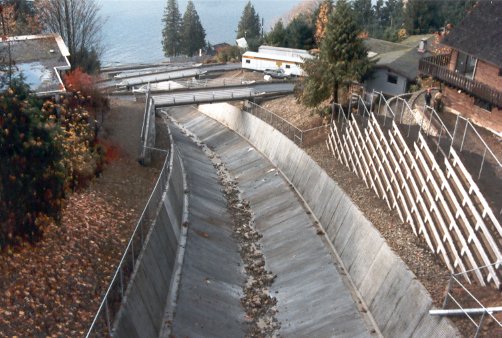
Concrete flume on Alberta
Creek, and BC Railway crossing in the lower part of Lions Bay |
 |
Harvey Creek retention
structure at Lions Bay. Highway 99 is in the central part of the
photograph. |
 |
Sediments from previous debris flows
exposed during construction at Harvey Creek. |
 |
Retention structure at Harvey
Creek. The streambed has been cleared, straightened and deepened
both above and below the structure.
The Highway 99 crossing is at the bottom.
|
 |
The bed of Harvey Creek below
the retention structure. Boulders have been set into the stream bed
with concrete. |
 |
View to the west over Howe
Sound across the upper part of the Harvey Creek retention structure.
The large concrete riffles are designed to
retain large debris (including boulders and logs) allowing water to pass
through.
|
 |
Construction of over-height bridges at
Harvey Creek.
(note old debris-flow sediments exposed on the
right) |
 |
Aerial view of the completed Harvey
Creek retention structure. |
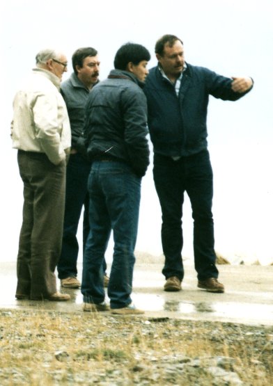 |
John Price (right), principal of Ker
Priestman Associates, and engineer of the debris flow retention structures and
stream channelization installations on Charles, Alberta and Harvey creeks
and nearby Magnesia Creek.
The Association of Consulting Engineers of
Canada awarded Ker Preistman Associates and Thurber
Consulting the Canadian Consulting Engineering Award
for 1986 for this work.
The photos were provided by Lee Price.
|
References
Evans, S. and Savigny, K , 1994, Landslides in the Vancouver-Fraser
Valley-Whistler region, in J. Monger (ed) Geology and Geological Hazards
of the Vancouver Region, Geological Survey of Canada, Bull. 481, p. 251-286.
Lister, D., Kerr, J., Morgan, G. and vanDine, D., 1984, Debris torrents along
Howe Sound, British Columbia; Proceedings of the 4th International Symposium on
Landslides, V.1, p. 649-654.