
This painting called “Howe Sound” by Peter and Traudl Markgraf captures some of the beauty of the coastal fiords of British Columbia, and shows, with a little exaggeration, the steepness of some of the slopes.
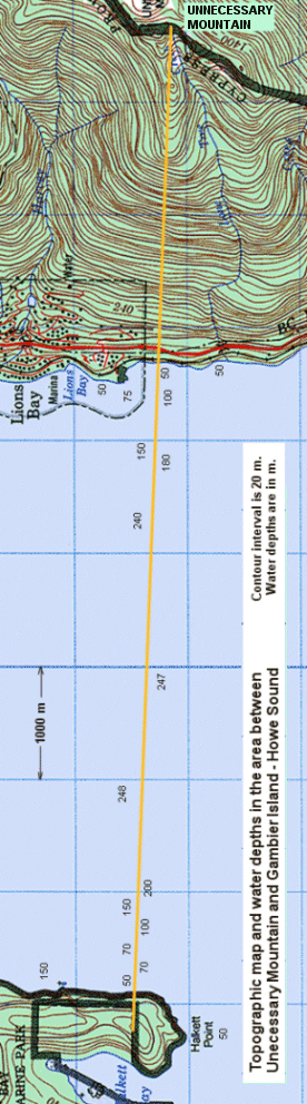
i) A topographic map
of the area between Unnecessary Mountain (above Lions Bay) and Halkett Point on
Gambier Island is available here.
The contour interval on land is 20 m.
The water depths are in metres, and are taken from the nautical chart for
this area.
Draw a topographic
cross-section from the peak of Unnecessary Mt. to the southernmost hill on
Halkett Point, showing the variations in elevation along the line marked in
yellow. Use the same horizontal
scale that the map is in (it should be close to 1:50,000 although this may vary
depending on your printer) and use a vertical scale of 1:10,000. (ie. 1 cm = 100
m). Show the water depths in Howe
Sound on your cross-section. Label
significant topographic and transportation features on the section.
Describe the shape of
the valley that is now Howe Sound, and how it relates to glaciation.
Comment on the implications that this has for slope stability along the
eastern shore of Howe Sound. For
some extra information have a look at: http://www.mala.bc.ca/~earles/howesound/
|
This painting called “Howe Sound” by Peter and Traudl Markgraf captures some of the beauty of the coastal fiords of British Columbia, and shows, with a little exaggeration, the steepness of some of the slopes. |
ii) A similar map for
the Mt. Price and Rubble Creek area is available from here.
(In this case the contour interval is 20 m).
Draw a topographic cross-section from the peak of Mt. Price to the BC
railway on the western side of the Cheakamus River.
Use the same vertical scale as in the Howe Sound exercise.
Label any significant topographic, geological and transportation features
on the section.
Explain the
geological origins of the plateau area between Mt. Price and the Barrier, and of
the Barrier itself, and speculate about how far back the Barrier has failed
since deglaciation.
For some help with
this refer to the satellite image of the Garibaldi Lake
area. You can also find some
information about this area on the internet.