| Lab 2a - Harmonic
amplification of seismic shaking Lab 2b - Microzonation assessment of amplification potential |
Lab 2a - Harmonic amplification of seismic shaking
The objective of this lab is to understand the differences in propagation of body waves (eg. P or S waves) at different wavelengths, and to see how the amount of ground shaking is affected by the relationship between the wavelength of the waves and the natural harmonic frequencies of geological materials. The exercise will be completed during the lab period and should be handed in at the end of the class. We will use the geology classroom (Rm 107/ Bldg. 370) for this lab.
Data from the harmonic amplification experiment: lab02a-data-07.xls
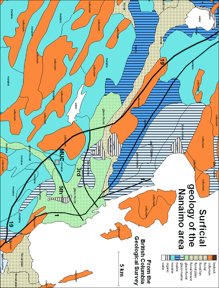
Lab 2b - Microzonation assessment of amplification potential in Nanaimo
In this lab we will be examining a surficial geology map of the Nanaimo area (ie. a map showing the distribution of unconsolidated surficial materials such as glacial deposits) with the objective of making some predictions about the potential for harmonic amplification.
Click here to have a look at the map.
Surficial Geology involves the mapping and description of the unconsolidated materials that lie on top of bedrock. These materials include clay, silt, sand, gravel and peat, and, in our region, are generally of glacial, fluvial or marine origin. They range in thickness from a few centimetres to tens of metres.
The thickness of surficial deposits plays a critical role in the amplification of earthquake waves. Significant amplification can take place where poorly-consolidated material is several to tens of metres thick. This map does not show thicknesses, but in the absence of that information, it can be assumed that colluvium – which is largely the broken material derived from weathering – is generally present as layers that are less than a couple of metres thick. In this region moraine – a.k.a. glacial till – tends to be up to a few metres thick. Marine and glacio-marine deposits are also typically in this thickness range. Fluvial and glacio-fluvial deposits (ie. stream deposits) can be much thicker, in some cases as much as tens of metres thick, and organic (peaty) deposits can also be quite thick.
The types of materials shown on the map can be
described as follows:
Bedrock
|
Exposed rock (While there are no areas of exposed rock shown,
there is a lot of exposed rock in the Nanaimo area. The outcrop areas are not shown because they are relatively
small, but they mostly lie within the areas marked as colluvium) |
Colluvium
|
The products of erosion of bedrock. Most areas mapped as colluvium also include extensive areas
of exposed bedrock. Colluvium
deposits are largely comprised of relatively coarse gravel and rock
fragments. |
Fluvial
|
The deposits of rivers and streams.
Grain sizes vary, but thick layers of sandy deposits are common.
Fluvial deposits are typically poorly-consolidated and loosely
packed. |
|
Glacio-fluvial |
Similar to fluvial, but deposited by streams that
existed during glaciation. Because
there is typically a lot of water flowing around during glaciation, some
glaciofluvial deposits can be very thick. |
|
Marine and glacio-marine |
Sand, silt and mud deposits formed in marine areas.
Within a few hundred meters of shore these deposits can be sandy
and silty, but otherwise they are quite clay-rich.
The existence of marine and glacio-marine deposits on land around
Nanaimo is a result of the fact that Vancouver Island was pushed down by a
heavy load of glacial ice, and did not rebound fully until a few thousand
years after the ice had left. |
Moraine
|
Material moved by glacial ice. Material is moved on top of, within and beneath an ice sheet, although
in many cases the sub-ice material is dominant.
Almost no sorting takes place beneath an ice sheet, so most glacial
till is a mixture of material ranging from fine clay up to coarse
boulders. Because of the
weight of up to several thousand metres of ice, sub-ice glacial till can
be very well compacted – and almost rock-like. |
Organic
|
Vegetative material, primarily from swamps. Vegetation
can accumulate to thicknesses of many metres in swampy environments.
The vegetation is typically mixed with silty and sandy sediments,
and is not well compacted. |