|
Overview of Spatial
Data
(based on Chapter 2 of
Heywood et. al.)
Primary vs. Secondary Data
(your survey notes vs. data from someone else)
Data vs. Information (raw
numbers vs. "meaning")
3 "Modes" (Dimensions) of Data
 |
temporal (time) |
|
spatial (location) |
|
thematic (description/attribute) |
Geo-referencing
|
metric (measure) vs.
non-metric (no measure)
 |
non-metric examples:
 |
landmark (Eifel Tower) |
|
street address (900 Fifth
Street, Nanaimo, BC, Canada) |
|
general description (south
slope of Benson) |
|
census tract, postal code,
counties, section/ quarter section, etc. |
|
|
metric
|
relative (check out the hottie
3 m to your right) |
|
absolute
|
geographic (lat./ long.) |
|
rectangular/ Cartesian (UTM
eastings & northings) |
|
|
|
|
datums (for x,y and z) |
Projections
(transformation of features on
earth/sphere/globe onto a shape that can be flattened)
|
4 properties can be distorted |
|
projection types: equal area vs.
conformal (also equidistant & azmuthal) |
|
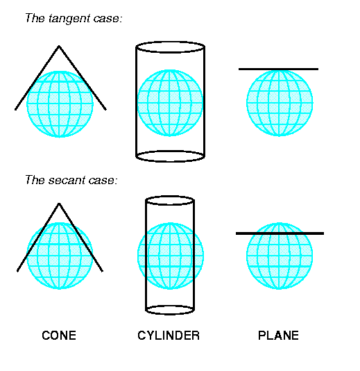
developable surfaces (shapes) -
cylinder, cone, plane |
|
tangent vs. secant |
|
standard line(s) |
|
scale varies on a map! |
Mapping Process
(remember your topographic map for FRST 111)
|
purpose
|
ultimately the mapmaker is
turning data into information to communicate meaning to a 3rd party |
|
decide on what information
and understand the audience (consider the difference in detail and
need for accuracy)
|
map of a pond and field for an
outing for school kids |
|
a road map for travelers |
|
a road map for outdoor
enthusiasts |
|
a road map for emergency
transportation planners |
|
|
your topog.
map - to show a specified level of topographic detail, as set by instructor
|
|
|
scale
|
obviously level of detail
to be mapped is a prime factor |
|
your topog.
map - set by level of desired detail and size of map sheet provided
|
|
|
real world features
|
the
real world phenomena (real world spatial entities,
real world features, real world things) that are to be mapped |
|
purpose of the map
determines what phenomena are to be captured |
|
your topog.
map - elevation plus planimetric detail (creeks, ponds, roads & trails) plus
thematic detail (timber types)
|
|
|
map representation
|
how are you going to represent
the various real world phenomena on a piece of paper |
|
(vector)
mapped features (mapped entity types)
|
points (0-dimension at map
scale) |
|
lines (1-dimension at map
scale) |
|
areas/ polygons (2-dimension at
map scale) |
|
|
your topog.
map - points for spot heights; lines for creeks, roads, trails; areas for
ponds and timber types
|
|
|
generalization
|
the world to too complicated to
be fully captured on a map - therefore we simplify - we generalize to
maintain clarity! |
|
reasons include:
|
purpose of map (map for school
kids will be intentionally simple) |
|
scale of map (on a small scale
map features are smaller and therefore simplified) |
|
technology (resolution of
satellite imagery, minimum thickness of lines we can see) |
|
"clarity" (we often simplify to
maintain enhance meaning - often resulting in increased spatial error!!) |
|
|
selected types of generalization
|
selection - what
features are selected depends on purpose of the map (e.g.
your topog. map - ignored soil types but focused on
elevations) |
|
simplification - scale
is the primary factor (e.g. your topog. map -
consider the difference in contour detail of a 1: 20,000 map vs. your map) |
|
displacement - features
in the real world are so close that you are not able to depict both on
your scale of map (e.g. a road that follows a river) |
|
smoothing - if source
data provides an un-naturally angular feature, smoothing improves the look
(e.g. your topog. map - you did not connect the dots
for you contour lines; you smoothed them)
|
|
|
|
map projection
|
depends on purpose of map and
which of the 4 parameters (distance, direction, area, & shape) you want to
preserve |
|
your topog.
map - you actually ignored this and simply drew a large scale plan
|
|
|
spatial referencing
|
for a general reference map it
would be logical to use a standard datum (NAD83) |
|
your topog.
map - your spatial referencing was relative to your baselines and was not
converted to 'real world coordinates'
|
|
|
annotation
|
text to aid in communication
(includes map title, date, legend, labels, etc.) |
|
your topog.
map - as set by Instructor |
|
Topology - a topic for another
day (if ever)
Thematic Data (a.k.a.
attribute data, a.k.a. descriptive data)
|
this is the descriptive data and
can be textual or numerical |
|
scales of measurement (numerical)
|
nominal (name or category,
provide identity, cannot do math (e.g. math on phone numbers would be
pointless) |
|
ordinal (order or ranking
but intervals are not determinate/ consistent, e.g. military rank, Likert
scale (rank from 1 - 5 your satisfaction), movie/restaurant ratings) |
|
interval (difference
between numbers is on a scale (so an increase of 1 interval is consistent
throughout the scale), but there is no absolute zero; e.g. temperature, IQ,
dates - therefore a number comparing 2 to 4 does NOT mean that the 4 is
twice as big) |
|
ratio (difference between
numbers is on a scale AND there is a 'real zero'; e.g. income (yes, you can
make no money and 4 dollars is actually twice as much as 2 dollars), height,
weight, age, etc.) |
|
Spatial Data Sources
|
census / survey (can be collated to
census or postal code tracts) |
|
air photos |
|
satellite images |
|
field data: GPS & traverse notes |
|
paper maps |
Data Standards - a topic for
another day (with data quality)
|